Why it matters
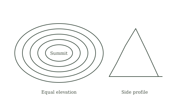
A contour joins points of equal elevation. Close spacing usually indicates a steeper slope at the map’s scale; wider spacing suggests gentler ground. Contours describe shape, not surface quality: a gentle slope may still be boggy or blocked.
What you’ll need
Tools
- Topographic map
- Pencil
Materials
- Local walking route
Work carefully, in order
The method
- 01
Read interval and units
Find the contour interval and elevation units in the legend. Distinguish index contours from intermediate lines. Count intervals carefully; five gaps between lines are not the same as five lines.
- 02
Trace a hillside
Choose two labeled elevations and follow the contours between them. Sketch a simple side profile. Identify where the slope steepens and eases, keeping the horizontal map scale in mind.
- 03
Find valleys and ridges
Follow lines where they bend across drainage features. Contour V-shapes crossing a stream generally point uphill, but verify with stream direction and labeled elevations. Do not infer a water source is flowing or safe from a blue line alone.
- 04
Compare routes
Draw a direct route and a gentler alternative around a slope. Count height gained and inspect cliffs, waterways, paths, access rights, and vegetation information. The shortest line can be the slowest or least safe walk.
- 05
Verify on familiar ground
Take the map to a known viewpoint and compare a few visible slopes. Note features too small for the map scale and changes since publication. Build recognition through repeated comparisons before depending on it in unfamiliar terrain.
Mistakes to avoid
- Ignoring contour interval
- Confusing map steepness with walking difficulty
- Assuming every closed contour is an ordinary hill
If it isn’t working
Shape is difficult to imagine
Draw a cross-section through labeled elevations.
Ground differs from map
Check scale, date, and your position.
Then & now
Historical context
Contour mapping compressed three-dimensional terrain into a portable reference that could be read without electronics.
The modern equivalent
Digital terrain models help visualization but can conceal detail at inappropriate zoom levels.
Sources & review
Editorial draft — specialist review pending. Written 2026-09-20. Sources support the stated scope; this page has not been professionally certified.
This entry describes general practice. A topic-specific source review is still required before it can be marked reviewed.
How this manual handles evidence →