Why it matters
A route card connects map reading to decisions the group can use. This example is an invented 8 km out-and-back woodland route on maintained trails, not directions to a real destination. The outcome is a leg-by-leg card with travel allowances, breaks, a return reserve and clear conditions for abandoning the objective. Local terrain and the slowest participant determine real timings.
What you’ll need
Tools
- Current detailed map with scale and contour legend
- Ruler, pencil, watch and calculator
- Official route conditions and forecast
Materials
- Fictional 8 km practice route
- Route card and trusted-contact copy
Before this skill
- Map Scale
- Reading Contours
Before you begin
Safety & limits
- This is arithmetic and map practice. Do not treat the imaginary timings or 2 km/h example as a rule for real terrain.
- Closures, injury, unsafe water, thunder and declining group capacity override the destination and the timetable.
- If location is uncertain, switch to the lost-person procedure rather than calculating a faster route through unknown ground.
Work carefully, in order
The method
- 01
Bound the route and map
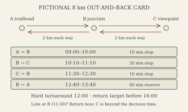
Mark A trailhead, B signed junction 2 km away and C viewpoint another 2 km away on a classroom map. The same trail returns C–B–A. Check date, scale, contour interval and actual mapped path, rather than measuring a straight line across hills. For a real trip verify official route descriptions, access, closures and conditions before selecting a distance or committing to travel.
- 02
Allocate each leg explicitly
For arithmetic only, assume the group’s practiced speed on comparable gentle trail is 2 km/h. Each 2 km leg then takes 60 minutes. Write four rows: A–B 09:00–10:00; B–C 10:10–11:10; C–B 11:30–12:30; B–A 12:40–13:40. Include the junction/viewpoint breaks between rows. This gives 4 hours walking plus 40 minutes planned stops; steeper or unfamiliar terrain needs different allowances.
- 03
Add return reserve and a decision time
Allow another 60 minutes for minor delays in this fictional exercise: planned completion including reserve is 14:40. The teaching scenario has a chosen finish-before-dark target of 16:00. Set an objective turnaround no later than 12:00: the assumed 2-hour return, a 10-minute break and 60-minute reserve give 15:10. This leaves 50 minutes before the chosen target, not a guarantee against unexpected terrain or injury.
- 04
Define checkpoints and safer alternatives
At B compare arrival time, group condition, weather and confirmed position. If the fictional group reaches B at 11:30 rather than 10:00, do not continue toward C: it cannot arrive before the 12:00 turnaround. Return along the known route. Mark escape points only where mapped access is permitted and actually usable; an unverified shortcut is not an escape route.
- 05
Transfer the plan to the contact
Write date, time zone, people, equipment, vehicle/access point, route card and safe-return message into the trip plan. Agree the actual overdue action with the contact; route timings do not by themselves create an escalation procedure. Hand the fictional card to another learner and ask them to state where the group expects to be at each checkpoint.
- 06
Debrief a changed condition
The leader introduces a blocked return leg or deteriorating weather. Identify which assumption fails and choose the earlier safe alternative or emergency procedure. Completion requires correct arithmetic, an explicit latest turnaround, a known return and a usable contact copy. After an actual supervised walk, record observed leg times and reasons for variation; do not turn one fast walk into a universal speed.
Mistakes to avoid
- Omitting the entire return journey
- Hiding rests and reserve inside an unexplained speed estimate
- Using an off-trail shortcut to recover a missed schedule
If it isn’t working
The elapsed time exceeds the plan at the first junction
Recalculate the known return with the group’s actual pace and conservative allowances; turn earlier if necessary. Do not chase the objective by removing rest or daylight margins.
A leg is closed or the expected landmark is missing
A closure changes the route; uncertainty changes the navigation decision. Use a verified permitted alternative or stop and assess rather than drawing a shortcut.
Then & now
Historical context
Kephart’s outdoor notebooks preserve a named early twentieth-century recordkeeping tradition. Modern route planning retains written observations while adding current maps, weather alerts and an acknowledged overdue plan. Archival notes are provenance, not a present-day closure or timing source.
The modern equivalent
Current official mapping, trip alerts and a maintained navigation device can complement field observations; keep an independent map and a plan for loss of power or signal.
Sources & review
Editorial draft — specialist review pending. Written 2026-10-06. Sources support the stated scope; this page has not been professionally certified.
- NPS — Hike Smart ↗
Choose a route for the group, check conditions, keep together and set turnaround limits. The arithmetic and imaginary route card here are original examples. Checked 2026-10-06.
- NPS — Trip Plan ↗
Itinerary and trusted-contact roles. Fictional route names, check-in times and escalation times here demonstrate recordkeeping, not a universal waiting period. Checked 2026-10-06.
- Western Carolina University — Kephart outdoor writing archive ↗
Documents Horace Kephart’s outdoor notebooks and the 1916 expansion of Camping and Woodcraft. Provenance for the written-record tradition, not evidence for modern shelter or medical procedures. Checked 2026-10-06.